
Cimarron and Oklahoma |
Monday
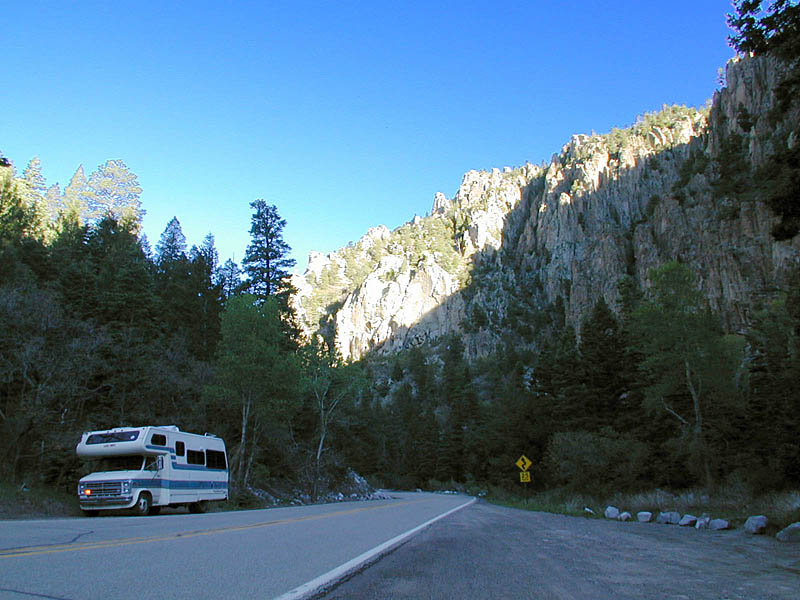
The view out the back windows is gorgeous as the sun rises. I took time out from typing this to photograph it. And now Gertie is all warmed up—her engine, I mean—and I'm ready to go. Wonder how far I'll get...? Monday noonThis getting off to an early start really works well! I had only about another half hour of twisty mountain roads (a motorcyclist would have loved all this, by the way) before I came out on the plain. But what a half hour! The morning sun lit up the spectacular scenery, so that around every curve I faced another stunning vista. I stopped several times to take photos. (Frequent pull-off spaces made this easy to do—my thanks to the New Mexico Highway Department!) I'm beginning to have confidence that by the time I get back, I will have enough truly topnotch photos to put together that joint show for the company cafeteria that I've talked about with my friend Paul SooHoo. 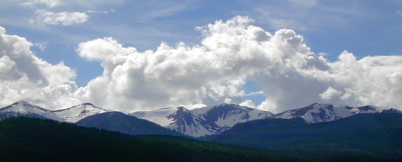
I remember from my boyhood that the Boy Scouts have their master campground, Philmont, in these Cimarron mountains. They couldn't have picked a better place. Back then a trip to Philmont was a boy's dream, second only to a trip to Disneyland. I didn't manage either back then...but better late than never! 
The rest of the way through New Mexico was flat and smooth; Gertie just hummed along at 60 mph. It was relaxing after all that mountain driving...though of course much less interesting to look at! In fact, after a couple of hours I began to feel a bit drowsy, so I pulled out an Atomic Fireball. I carry these fiery cinnamon-flavored jawbreakers in the glovebox as insurance against just such situations. It is not possible to be drowsy while an Atomic Fireball is searing your mouth! Just after 10:00 a.m. I entered Oklahoma, and immediately the roads got much worse. The stretch of two-lane Oklahoma highway (Rt. 64/512) I'm on is narrow (two-foot shoulders in NM have turned to 6" shoulders in OK) and bumpy. And I can see that it's going to be a complicated mess getting across the top of this state. The main east-west route is I-40 (about which I've heard so many bad reports—"It'll shake your RV to pieces!"), but it runs through the middle of the state. Going west to east across northern Oklahoma means following a network of secondary roads, with lots of changes and lots of places to make wrong turns. Navigation: high-tech, low-tech or both?
The GPS also works surprisingly well as an altimeter—something GPS receivers are not noted for being good at. I've been checking it every time I pass through a town that has its altitude posted ("WELCOME TO EAST MUGWUMP - ALT. 6,524"), and it has never been more than 80 feet off. I should talk a little about navigation. When I first contemplated this trip, I had high-tech dreams of my new PowerBook sitting at a convenient angle on the Jotto Desk arm mounted in the passenger's side. It would be running Street Atlas USA mapping software and, hooked up to my new GPS receiver, would always show me exactly where I was on the map. It didn't work out that way. First, I never learned to make Street Atlas do the tricks I wanted it to. I blame its lousy user interface plus the fact that it took to crashing and freezing every time I tried to do anything with it. Then there was the problem that my new G3 PowerBook, like all new Macs, has no serial ports, while the GPS receiver requires one. (As far as I can tell, nobody makes a USB-based GPS receiver—when are the idiots going to catch on that the old RS-232 serial port is dead?) I could remedy that with a serial-to-USB adapter, and in fact I tried it—but the KeySpan adapter I bought draws so much juice from the USB bus that it requires a separate AC-powered USB hub. I have one of those too, but...it just got to be too many boxes and cables to run a piece of flaky software. I tried driving with a road atlas on the passenger's seat, but it's impossible (and dangerous!) to read that tiny print while driving. And I'm not at my best interpreting maps anyway—I prefer step-by-step instructions, as in a computer program or a recipe. That's just the way my slow, methodical mind plods along. 
So here's what I've been doing: first thing in the morning or when I'm stopped for a break, I spread out the National Geographic Society road atlas (which I prefer to the more common Rand McNally atlas) on the table and look up my route. Then I dictate it into my Olympus V90 pocket digital voice recorder: "From Anderson, take Rt. 71 south past Bentonville and into Fayetteville, then get on 71B." "Go south 16 miles on 71B, then turn left at the Conoco station onto Rt. 34C." And so forth. While I'm driving, I can fish the recorder out of my pocket and push the "play" button without taking my eyes off the road, and it tells me exactly what to do in a form I can understand. The Olympus recorder has several folders, and each message is a separate file. I record the legs of my route as separate messages so I don't have to listen to the day's whole itinerary just to get to the last part of it. I store these directions in the "A" folder. I use the "B" folder to record memos to myself while on the road—things to mention in this journal: "So far, almost all of the RVs I've seen have been heading in the other direction. Do they know something I don't?" One of these notes says to mention that Oklahoma and Arkansas too seem to be infested with big dark-colored butterflies. I have yet to get close enough to one to photograph it, (though god knows enough of them have bounced off my windshield), but from what I can see they are mostly black with a small orange/brown pattern near the center of the wing. I tried to look them up in my Peterson's Guide, but couldn't find anything that fit this description. They're not colorful enough to be monarchs...I don't know what they are, but there sure are a helluva lot of them spread across hundreds of miles of plains. Another random note: of all the motorcyclists I've seen in the past week and a half, only two had helmets. 99 out of 100 were either bareheaded or wore scarves or bandannas. A couple have been carrying helmets on the bikes—but not on their heads! Apparently these western states have no helmet laws (or no enforcement), and the bikers here don't care enough about their brains to protect them. Or maybe they haven't any. Rugged individualism is fine, but as Gary Villere points out, my tax dollars pay for medical care of the human vegetables that result from this behavior. I stopped for lunch outside of Boise City, Oklahoma at a Dairy Queen, feeling the need for a vanilla milkshake. Once inside, I succumbed to the temptation to buy a basket of chicken tenders that turned out to be mediocre at best...ate half of them and saved the rest for later. Maybe I can redeem them with a homebrew sauce. Eight bucks wasted. Ah, well. Time to move on... Monday nightAs predicted, I soon tired of flat and level Oklahoma driving and wished for more scenery like this morning's. But at least I made good progress: 360 miles altogether, which I think just about puts me back on schedule. This is a good thing, because I may want to spend two days at the USAF museum...or in Pittsburgh, for that matter. Tomorrow will be another long driving day—Oklahoma is a W-I-D-E state!—but I expect to reach Terra Studios in western Arkansas by tomorrow evening. 
Today's drive would have been fairly easy except that I had to fight a constant side wind, and a brisk one too—I'm guessing at least 30 mph with higher gusts. It blew across the road from my right all day as I headed east, forcing me to exert a constant and tiring torque on the steering wheel. I stopped at a Wal-Mart—first one I've seen on this trip!—outside Guymore and picked up a few things to help organize Gertie—bookends, more Velcro and such. I noticed that the average humidity is low enough here that people use evaporative coolers—there was a whole aisle devoted to their pumps, cleaners and other accessories. It felt much more humid than either Arizona or New Mexico, though—about 50%-60%, I'd say. I was working up a sweat just driving. I continued down the road for another uneventful three or four hours, finally stopping at Boiling Springs State Park. (I got directions from a friendly UPS driver in a gas station where I stopped to ask the way—good person to ask for directions!). I'm getting reasonably good at finding places to stay, something I was nervous about before I started. This park has a very "park-like" RV area, with hookups and pads fairly closely spaced in a manicured landscape. It's attractive overall, but nothing like yesterday's deserted and idyllic wilderness site! After parking and leveling, I discovered to my annoyance that I'd left my gas cap at my last stop—something I'd feared would happen, as it is black and easy to lose sight of. Fortunately Gary—bless him!—had packed an extra gas cap with the other spare parts. (Perhaps he's had this experience too? Or maybe he's just prudent.) I'll have to either find a way to tether the cap or come up with a temporary storage place on the coach, such as my Accord has, so I won't leave the cap on a gas pump the way I did this time. The second thing I discovered was that the power at this site is unreliable. The 15A outlets were both old, corroded and electrically intermittent, but the 30A outlet seemed to work, so I hooked up with an adapter. But as soon as I turned on my air conditioner (I was pretty sweaty by the time I arrived), and anxious to cool off), my breaker popped. So I moved to the site next door, which had good power. That'll teach me to check the electric power first before parking! A taste of the Ol' Muddy
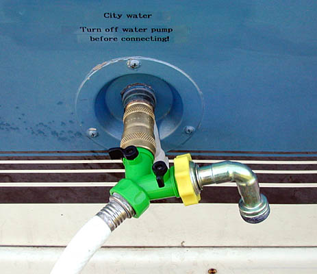
The third thing I discovered was that this campground's water was as brown as chocolate milk. I found this out thanks to a little gadget that I put together from odd garden-hose parts...a veritable plumber's nightmare. Its main purpose is to let you bleed the air out of your fresh water hose rather than force it into your system, possibly causing an embolism in your water heater.
So I contented myself with electricity for the air conditioner. A quick shower left me refreshed, and I dined sumptuously on leftover chicken (reheated in the microwave), fresh avocado slices and cherry tomatoes, with a sarsaparilla float for dessert. It was so delicious that I couldn't stop smiling. I'm so happy with Gertie! |
 I ought to mention that the Garmin 12XL GPS receiver started working reliably a few days ago and has been fine ever since, although I'm still not smart enough to use it for anything but a speedometer and compass. (Those functions alone are quite useful, though.) What made the difference? I disconnected the Mighty Mouse II external amplified antenna, which apparently was making things worse instead of better! I very much doubt that this was the antenna's fault—it improved reception greatly when I tried it at home. Most likely I either have it in a bad position, or I have a pinched cable. I'll have to look into it after I stop this evening. (Later: it turned out that the antenna, which I'd Velcroed to the inside of the upper overcab window, had come unstuck and fallen down inside the aluminum body, which shielded it from the satellite signals.)