


An Arizona excursionJuly 14, 2008—When you're retired, sometimes it's hard to remember how time and schedules tyrannize the rest of the world. Most people get only a few weeks of vacation from their 9-to-5 jobs... so they rush from place to place, trying to pack in the maximum amount of sightseeing before heading home, exhausted. I've done it myself: thirty years ago when I was young and foolish, I toured the southwest in less than three weeks—starting and ending at my New Jersey home! As you can imagine, much of the trip was a blur. By the time I got back, I felt as if I needed a vacation from my vacation, just to recover from all that driving.  These days, thank goodness, I lead a more relaxed life. Instead of dashing across the US and back in three weeks, I often spend that much time in just one park... then drive seventy-five or a hundred miles up the road to the next park. In the past two years of full-time RV travel, I've averaged about twelve miles a day. In short, as a traveler, I couldn't win a race against a snail. So when my old New Jersey friends Paul and Carolyn SooHoo told me that they'd be passing my way early in July, and hoped to stop in on their way from Albuquerque to Flagstaff (323 miles), I sighed. By driving all day to get from one city to another, they'd miss some of the best parts of New Mexico, and I'd be lucky to spend an hour or so with them before they had to hurry on their way. But, I reminded myself, they were on vacation—they had a schedule, they had reservations, they had all the constraints I used to have. That's why last week I interrupted my leisurely routine to do a five-day, 700-mile excursion into northern Arizona and back, ending up exactly where I started. In less than a week, I drove as far (and used as much gas) as I normally would in two months. But it was worth it, because I got to spend time with good friends whom I hadn't seen in the three years since leaving New Jersey. Paul and Carolyn were bound for Page, Arizona, to photograph the Lower Antelope slot canyon there. I decided to tag along—I hadn't had a chance to photograph anything really spectacular in awhile, and it would let me spend several days with them instead of just an hour or two. To that end, I left Bluewater Lake State Park in New Mexico and drove the 225 miles west to Flagstaff to meet Paul and Carolyn. Early in the evening I pulled into the Bonito Forest Service campground just north of the city, and a few hours later my friends arrived in a rented car. 
Photo: Paul SooHoo
I had invited them to spend this first night in Skylark, rather than find a motel room. We ate a late dinner, and then sat up talking. Paul and Carolyn teach math and science, respectively; they're photographers, Mac users, and have an avid interest in science and technology, so we had plenty to talk about. As midnight approached, I made up Skylark's rear couch into a double bed, and closed the partition door that splits the coach roughly in half. My friends slept in back, while I slept over the cab as usual. It was their first night in an RV, but aside from my cat Alix pawing at the door in the early morning (she just wanted to know what was going on back there), they said they were quite comfortable. In the morning after breakfast they climbed back into their rental car, and we set out in a convoy for Page, 135 miles to the north. Route 89 passed through some of the most desolate country I'd yet seen. For much of the way, the only signs of human occupation were shabby roadside stands offering Indian-made trinkets, and at least half of these were abandoned and falling down. (I ought to mention, by the way, that when I browsed a Native American-owned gift shop in the Jemez Pueblo last year, I was amused to find that a large percentage of the "handcrafted by Indians" merchandise came from the kind of Indians who live in New Delhi!) At one point a construction project halted traffic for ten or fifteen minutes. But sitting still in traffic is no hardship for a motorhome owner: I set the brake, walked back into the coach, used the bathroom, and fixed myself a quick snack. I was back in the driver's seat well before traffic got moving again. As the road descended into the desert, the temperature, which had been cool and comfortable in Flagstaff, soared. I don't normally bother with reservations, but this time I had made one at a commercial campground in Page. With triple-digit temperatures in the forecast, I knew I'd want to be plugged in with the air conditioner running for the duration of our stay—for Alix's sake as well as mine. I knew there'd be no shortage of power—the rows of high-tension towers and transmission lines converging on our destination were mute testimony to that, and when the gigantic Navajo Generating Station reared its 775-foot stacks (and their plumes of coal smoke) over the horizon, I knew I was getting close. 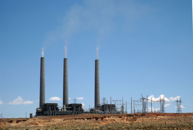
After hours of driving through desolate wilderness, the city of Page appears seemingly out of nowhere, like a mirage in the desert... an incongruously bustling community of Wal-Marts, restaurants, hotels and all the chain stores you'd expect to find in suburban New Jersey. Page started as a boom town, founded in 1957 when work began on Glen Canyon Dam. Now it's a magnet for tourists enjoying the artificial lake that the dam created. Their massive powerboats and palatial houseboats are visible everywhere in the town's many storage lots, and of course on the lake itself. To my surprise, I found that Page was swarming with Germans. I knew that Europeans had been taking advantage of the weak American dollar, but I never expected to see this many from one country. At Paul and Carolyn's hotel, almost all the guests were conversing in German. So were the guests at my RV park, most of them driving motorhomes rented from CruiseAmerica or El Monte. So were the occupants of the other tables in the Italian restaurant where we ate that night. And so were the tourists in Lower Antelope Canyon the next day. It got to the point where if I brushed against somebody, I'd mutter "Schuldig!" instead of "Excuse me," because four times out of five the person was German. Having been in the southwest for a few years now, I'm used to hearing Spanish spoken all around me, but I've never before been surrounded by so many Germans. It was quite an odd feeling. Lower Antelope CanyonThere are actually three slot canyons near Page: Canyon X, and Lower and Upper Antelope Canyons. Canyon X is the most remote of the three; only a few people are allowed in at one time, but admission costs $150 or more. The Antelope canyons are busier, but much less expensive. The upper canyon is wider and more easily accessible, but it's also the more tourist-infested of the two, so we chose the lower canyon. It's just outside of town, and when you arrive, there's nothing to see except a very small sign, a parking lot flanked by a row of portable toilets, and a ramshackle shelter where the Navajos take your money. It costs $26 per adult to get in, and for your money you get... admission. There's no guide. No tour. No signs, even. $26 is just the price of getting to the other side of the fence for half a day. That may sound like a lot of money, but I had no problem with it. The canyons are on Indian land. They can charge what they think the traffic will bear, and if we don't like it, we can go elsewhere. There aren't a lot of ways to earn money in this godforsaken place, so I don't begrudge them this one. It's hard to describe the slot canyon, and most of the pictures I've seen—including my own—don't give you any sense of scale. The name itself is deceptive. "Canyon" evokes an image of a deep valley, perhaps half a mile wide and several miles long. But Lower Antelope Canyon is at most ten feet wide, thirty feet deep and barely a quarter mile long. At the surface, it looks like nothing more than a crack in the ground. In fact, after we paid our admission fees and walked back behind the shack, we didn't know where to enter the canyon. There was no sign, and nothing that looked like an entrance... just a landscape of irregular sandstone with a few cracks in it. It took us five minutes of wandering around to discover that we could walk down into one of the cracks... 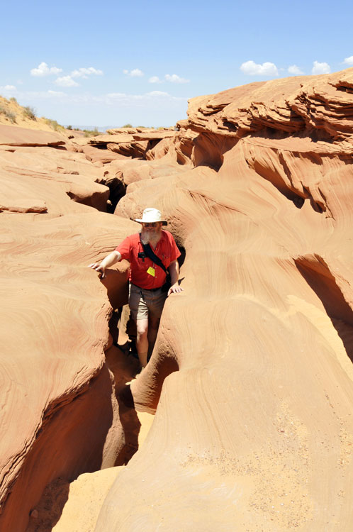 Photo: Paul SooHoo
... and that once below the sun-baked surface, there were a few metal stairs allowing us to descend ten or fifteen feet into a slightly wider space, where we found ourselves in an underground wonderland of narrow, flood-sculpted sandstone passages.  Photo: Paul SooHoo
Although we were there in the middle of the day (the best time to see these canyons), there wasn't much direct sunlight, apart from an occasional sunbeam. The light from above was mostly indirect; reflected from the sandstone walls, it gave everything a golden-orange-rosy glow.  Paul had brought his digital SLR and heavy-duty tripod. I had opted for an ultra-lightweight approach: I carried my tiny (smaller than an Altoids tin) Canon SD1100 and a cheap, lightweight Vivitar tripod. As it turned out, carrying any tripod in those tight passages is pretty awkward, and as soon as you set it up, you're blocking traffic. I shot mostly handheld, but I would have done better with a Gorillapod or similar flexible mini-tripod—something I could brace against any convenient surface to steady my camera. I did a lot of that anyway, and made out all right, despite the fact that it's surprisingly dark in some parts of the canyon. I even shot a few stereo pairs. Paul, of course, got better quality photos than I did, but he worked harder at it. I had told myself in advance that even if none of my pictures turned out well, I would enjoy just seeing the place—something I sometimes get too wrapped up in photography to do—and I did. 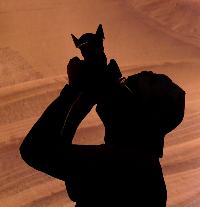 Some of the shapes carved by millennia of erosion were simply fantastic. This futuristic-looking silhouette projected three or four feet from the wall, just above head level. What sculptor could have imagined such a thing?  The width of the canyon varied from as little as six inches at floor level to as much as six feet in places. Many times we had to turn sideways to squeeze through a narrow passage, only to emerge into a wider space ten or twenty feet further on. In one alcove, a clump of tumbleweed perched at eye level on a shelf of pinkish-gray stone, while a reddish half-dome arched over it. I suspect that someone had placed it there deliberately, but in any case it made a lovely still life.  I guess it's obvious that this is not something you'll want to do if you're claustrophobic. I'm not, at least ordinarily... but by the time we were about three quarters of the way through the long, twisty canyon, even I was beginning to feel a twinge. It wasn't like crawling through a cave—there was plenty of light, air, and ample headroom—but the thought that we were going to have to retrace our steps through all those tight squeezes began to weigh on my mind, and I stopped once or twice in one of the wider places to breathe deeply for a minute. Carolyn, who was acting as Paul's bearer, was looking a little tired too. 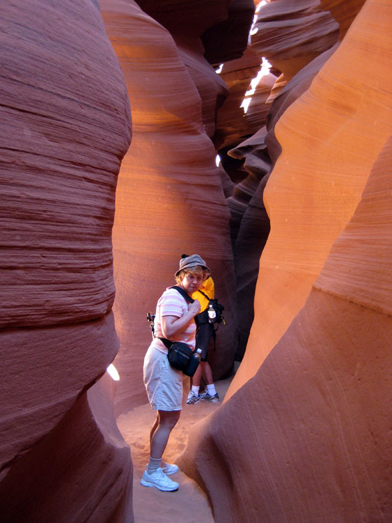 As it turned out, there was a ladder to the surface near the end of the canyon, so we could have climbed out and walked back. I climbed all the way to the top, nearly burning my hands on the sun-baked metal railings in the process. But after looking around at the scorching rock, I decided that a quarter-mile walk in the blinding sun had less appeal than the cool depths of the canyon, so I climbed back down again. And heading back, I found the claustrophobia was gone, banished by the knowledge that I was on my way out. After a couple of hours in Lower Antelope Canyon we were all ready for lunch, so we stopped at a MacDonald's and bought just enough of their food to feel no guilt about sitting in their air-conditioned dining room, eating from the cooler of more wholesome food that we'd brought with us. I'll cheerfully admit that my vanilla MacDonald's shake was very welcome, since by then it was over 100° F. outside. Then we headed over to the Glen Canyon Dam visitors center, where we'd signed up for the 2:30 p.m. tour of the dam. Glen Canyon DamThe early 1950s were a time of bitter controversy in the area along the Colorado river. On one side was the U.S. Bureau of Reclamation, lead by Commissioner Floyd Dominy, which proposed a multi-billion-dollar plan to dam the Colorado in ten places, flooding huge areas to create reservoirs. True to his name ("Master"), Dominy strongly believed in subduing nature for human use. He once summed up his philosophy by saying, "I have no apologies. I was a crusader for the development of water. I was the Messiah... Nature can't improve upon man. We're probably the supreme being." He even proposed to flood much of the Grand Canyon. The Bureau's plan was backed by powerful members of Congress from western states, including presidential hopeful Barry Goldwater, who were eager for the cheap hydroelectric power, water rights and tourist destinations it would create. Arrayed against the project was a coalition of conservation groups lead by the Sierra Club, which organized an unprecedented nationwide campaign to stop one part in particular: a proposed dam at Echo Park, Colorado, which would have flooded Dinosaur National Monument. The groups argued, not unreasonably, that if national parks and monuments could be flooded at the whim of the government, then nothing was safe. In effect, the declarations establishing such monuments "in perpetuity" would be rendered meaningless. The conservationists ended up making a fateful compromise: in exchange for the deletion of the Dinosaur National Monument dam, they accepted a dam at little-known Glen Canyon, Arizona. Later, when members of the coalition traveled down the Colorado through Glen Canyon, they were horrified at what they had given up: the reservoir would flood a canyon system that reportedly rivaled the Grand Canyon in beauty, including more than ninety side canyons; and more than 250 archeological sites would be destroyed. Sierra Club Director David Brower later called the decision one of the biggest mistakes of his career, and even Barry Goldwater later expressed regret that he had voted for the dam. But Congress had approved the dam, and construction went forward. Pouring concrete 24 hours a day, seven days a week for more than three years, Glen Canyon Dam was built at a cost of nearly 300 million dollars and 17 workers' lives. Dedicated in 1966 by Lady Bird Johnson, the 583-foot-high dam is responsible for Lake Powell, now a popular tourist destination. As for Floyd Dominy, he was fired in 1969 on orders from Richard Nixon, after Dominy's heavy drinking, foul mouth and sexual improprieties (he was notorious for propositioning coworkers' wives) became too much of an embarrassment.  In addition to flooding Glen Canyon and creating Lake Powell, the dam has had another effect... one that I hadn't heard about until I was reading up on the subject. A 1996 Bureau of Reclamation study estimates that 8% of the Colorado River's flow—almost a million acre feet annually, worth millions of dollars—is lost every year to evaporation from Lake Powell's huge surface area and seepage into its banks. I don't know for certain whether this is typical, but if it is, large amounts of water are being lost at every dam along the Colorado, which may at least partially explain why that river is running out of water. Glen Canyon Dam certainly has its benefits. Most obviously, it has given a huge boost to the tourist economy of the immediate area. And it generates electricity: more than a gigawatt comes from its seven operating generators. (One of the eight generators is always under refurbishment; in the photo below, you can see the one they're currently working on at the left.) The sale of power to the surrounding region over the years has repaid a substantial part of the dam's construction costs. Our tour of the dam's interior was quite interesting. The guide, a pleasant young Navajo man, first took us out upon the top of the dam itself. It was a dizzying view down to the powerhouse five hundred feet below! Then we were taken inside the dam, where we saw one of the many access passages in its interior. One purpose served by these passages is to drain off the 1,500-2,000 gallons per minute of water that leaks through the dam's wall. This leakage is collected in channels, and dumped into the Colorado river below the dam. (The Bureau of Reclamation prefers to use the term "seepage"... but if my basement walls were passing 2,000 GPM of water, I'd probably choose a different word!) We also got to see the powerhouse, albeit from a glassed-in viewing gallery. Its massive generators reminded me of the motor-generator building at my old employer, the Princeton Plasma Physics Lab. There's something fascinating about really BIG machines! 
After the tour... we drove back to Flagstaff! Yes, having spent one whole day in Page, at around four in the afternoon we said our goodbyes and piled into our vehicles for the three-hour drive back. I was headed for the Bonito Campground, while Paul and Carolyn had a motel reservation in town. It was an all-too-brief visit, but it was a lot better than seeing them for an hour as they passed by Bluewater Lake. 
Bonito is a very pretty campground, by the way. It's built in wooded, rolling terrain covered with volcanic cinders from the nearby Sunset Crater volcano. The only drawbacks are that it has no dump sites or water for filling tanks, and that the pull-through campsites are the smallest I've ever seen—barely big enough for a van. I found myself a back-in site and had no problems. By the way, the signs at the Bonito Campground entrance say that dry camping (the only kind offered) costs $16 a day, plus $8 for any additional vehicles... but the camp hosts said that this doesn't apply to towed cars. Apparently if you tow it in, you don't have to pay extra, but if you drive it in, you do. I'm not sure I see the logic, but I wasn't in a position to argue. Since the SooHoos drove their rental car in on the first night, I paid. Carol and BillThe next morning, after tidying up the rig, I drove a whole eight miles to the house my friends Carol and Bill Phillips are renting north of Flagstaff. Carol is a friend from my PPPL days—although retired, she still produces their annual "Highlights" report. She and Bill moved out to Flagstaff after they retired, and they're building a home in a wooded suburb. As with most houses, it isn't going to be ready on time, so they've had to do some juggling, renting a house to live in and storing most of their belongings until the Certificate of Occupancy is ready... supposedly in just a few weeks. Carol and Bill took me out to see their new house and meet their builder, Skip. As always happens when I see a house these days, it appeared absolutely enormous, even though I know by American standards it's not. But after three years of living in an RV, any house looks gigantic to me. Heck, their master bathroom is probably bigger than my entire home! 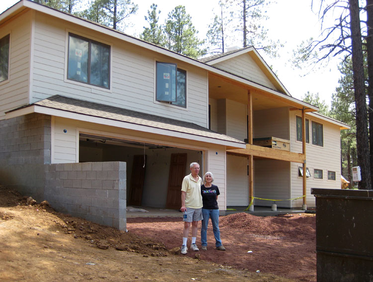
Anyhow, the house looks as if it's going to be very pleasant to live in, with lots of windows so that it should get plenty of light, even though it's in fairly dense woods. Carol and I walked around taking pictures—she's been documenting the whole construction process—and then we headed back for a delicious pasta supper that combined the best of her larder and mine.  Next morning it was back to Bluewater Lake... a longish 225-mile drive, but a pleasure to get back to New Mexico and settle down for awhile! |
 (click for a larger view)
